Create a new project
For creating new project use the New project link on the Projects tab.
Input data format
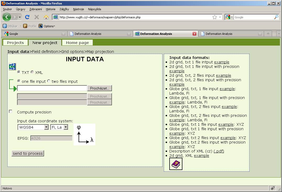
Input data is entered a a plain text file that contains the coordinates of the points and their displacements, or as two plain text files containing the coordinates of the points at two different stages of measurement.
-
Plane
- 2d grid, txt, 1 file intput example
- 2d grid, txt 1 file intput with precision example
- 2d grid, txt, 2 files input example
- 2d grid, txt, 2 files input with precision example
-
Globe
- Globe grid, txt, 1 file input example: Lambda, Phi
- Globe grid, txt, 1 file input with precision example: Lambda, Phi
- Globe grid, txt, 2 files input example: Lambda, Phi
- Globe grid, txt, 2 files input with precision example: Lambda, Phi
- Globe grid, txt 1 file input example: XYZ
- Globe grid, txt 1 file input with precision example: XYZ
- Globe grid, txt 2 files input example: XYZ
- Globe grid, txt 2 files input with precision example: XYZ
-
Input data entering

-
Select file(s)
To select a file(s), click the button Browse ....
If the file contains precision of points or shifts, the user can check the box "Compute precision" and the program will then calculate the precision of the strain tensor.
-
Select coordinate system
Allows you to choose a coordinate system of input data. Some coordinate systems are listed in the drop-down list. If the data are in a different coordinate system, the user can use EPSG code.
After pressing "Send to process" the input files are sent to the server and a page with definition of fields is displayed.
-
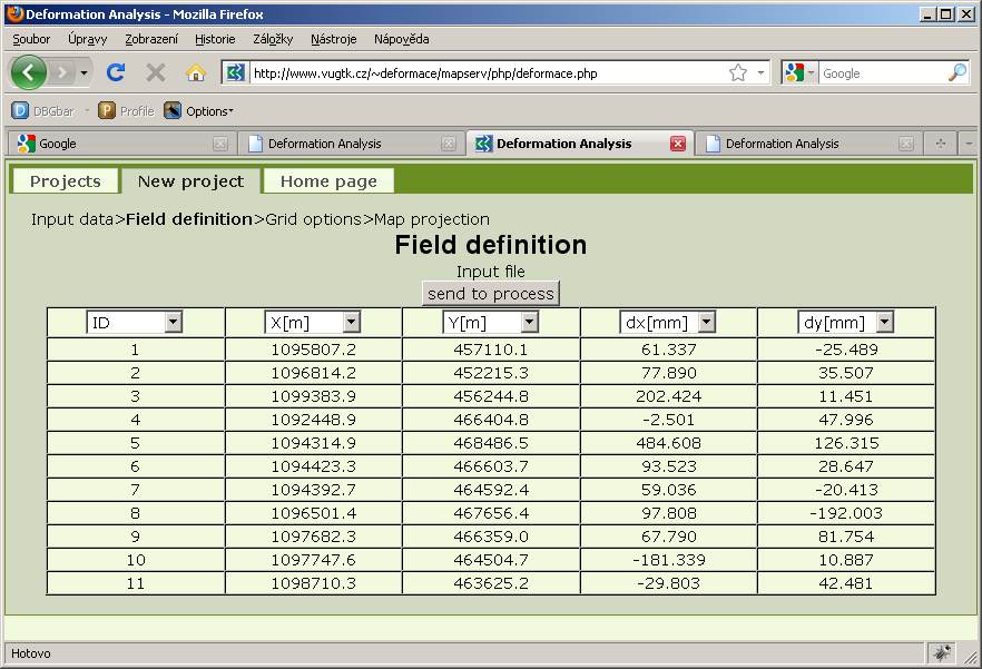
Fields definition
On the site Fields definition user defines the order of input data columns. There is no need to use a predefined input format. The application checks whether all columns necessary for the calculation are defined. Point number can contain all alphanumeric characters and is not limited to numbers. Furthermore, the application checks whether the coordinate values and shifts are the numberic values and reports possible errors.

-
Grid options
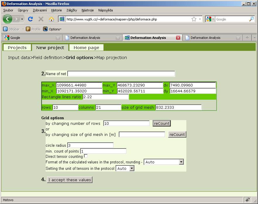
Here the user enters the parameters necessary for calculation, eg. the parameters of square grid for the interpolation of shifts field and the calculation of deformation field. It's necessary to specify either the number of rows or the grid cell size.

-
Project Name
Name that appears in the project panel.
-
Information about grid
Shows the minimum and maximum coordinates and their difference. Furthermore, the number of columns and rows according to the current grid settings.
-
Setting the number of rows and columns
You enter the number of rows or size of the grid cell. After entering the required values press the Recalculate button to refresh the displayed value.
-
Direct tensor calculation
This option allows you to calculate tensors directly from the derivations of the interpolation surface.
-
Setting protocol format
Format of the calculated values in the protocol and rounding - sets the format and number of decimal places for numbers in the protocol. Choice Auto is trying to set the optimal number of decimal places. If the results are not satisfactory, the number of decimal places can be set manually or numbers can be displayed in scientific notation.
Deformation tensors units in the protocol - allows you to set the units of tensors in the log. Choice auto to set units according to the size of the given points area.
-
View results
After setting the parameters press button "I accept these values."

-
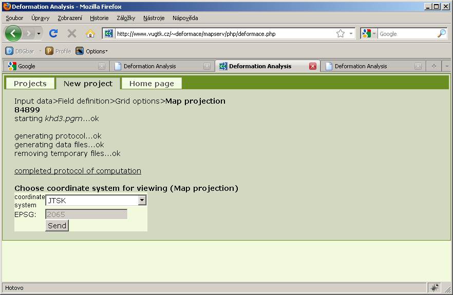
Choice cartographic projection
User can select the cartographic projection for the map window. The form offers most widely used projections more can be specified using EPSG code. Transformation is done by using PROJ.4. Send button displays the Map window with specified cartographic projection.
-
Protocol
The link "complete calculation protocol" shows numerical results of the calculation.
